Why Do Some Cities Feel More Walkable Than Others?
Some streets invite you to keep walking while others make a short trip feel exhausting. The difference comes from much more than having a sidewalk.
Two cities can have the same population, similar weather, and streets full of shops—and still feel completely different on foot.
In one, a 15-minute walk barely registers. Cafés, homes, parks, stores, and transit stops appear naturally along the route. Intersections arrive frequently. Crossing the street feels manageable. There is shade, activity, and always something ahead.
In another, walking half the distance feels like work. The sidewalk disappears, a six-lane road blocks the direct route, buildings are separated by parking lots, and the nearest useful destination is farther away than it looked on the map.
That difference is walkability.
And it is not determined by sidewalks alone.
A city feels walkable when its destinations, street network, buildings, transportation system, public spaces, and pedestrian environment work together so that walking feels practical, direct, comfortable, and worthwhile.
Walkability Begins With a Simple Question: Is Anything Close Enough to Walk To?
A beautiful sidewalk is not very useful if everything you need is three miles away.
One of the strongest foundations of walkability is proximity to destinations.
Homes need reasonably convenient access to some combination of:
- stores
- cafés and restaurants
- schools
- workplaces
- parks
- services
- entertainment
- public transportation
This is why land-use patterns matter so much.
Imagine a neighborhood consisting almost entirely of detached houses. The streets may be quiet and pleasant, but if grocery stores, workplaces, restaurants, and services are concentrated several miles away, most everyday trips still require another form of transportation.
Now imagine a neighborhood where homes sit within walking distance of shops, cafés, schools, offices, and a transit station.
The second environment gives walking a purpose.
The U.S. Environmental Protection Agency’s National Walkability Index incorporates land-use diversity as one of the variables associated with walking. Research reviews likewise consistently identify access to destinations and mixed land uses as important features of walkable environments.
The principle is straightforward:
People are more likely to walk when useful places are actually within walking distance.
Research on walkability consistently points to access to destinations as one of the strongest recurring factors.
A neighborhood may have beautiful sidewalks, but if homes are separated from shops, schools, transit and everyday services by long distances, many ordinary trips will still require another mode of transport.
Short Blocks Can Make a City Feel Smaller
Distance on a map is not always the distance you have to walk.
Street layout determines whether pedestrians can take direct routes.
Consider two locations that are 1,000 feet apart as the crow flies.
In a dense street grid with frequent intersections, you may be able to walk almost directly between them.
In an area dominated by large superblocks, highways, gated developments, rail yards, or enormous parking lots, the same journey may require a long detour.
This is why street connectivity matters.
The EPA’s National Walkability Index uses intersection density as one of its core measures. More pedestrian-oriented intersections generally create more possible routes and reduce the need for long, indirect trips.
Older city centers often demonstrate this clearly.
Their blocks may be relatively short, producing frequent intersections and many possible paths.
By contrast, environments built around high-speed automobile travel often contain much larger blocks.
A destination may look close.
The available walking route may not be.
A Sidewalk Is Necessary—but It Is Not Enough
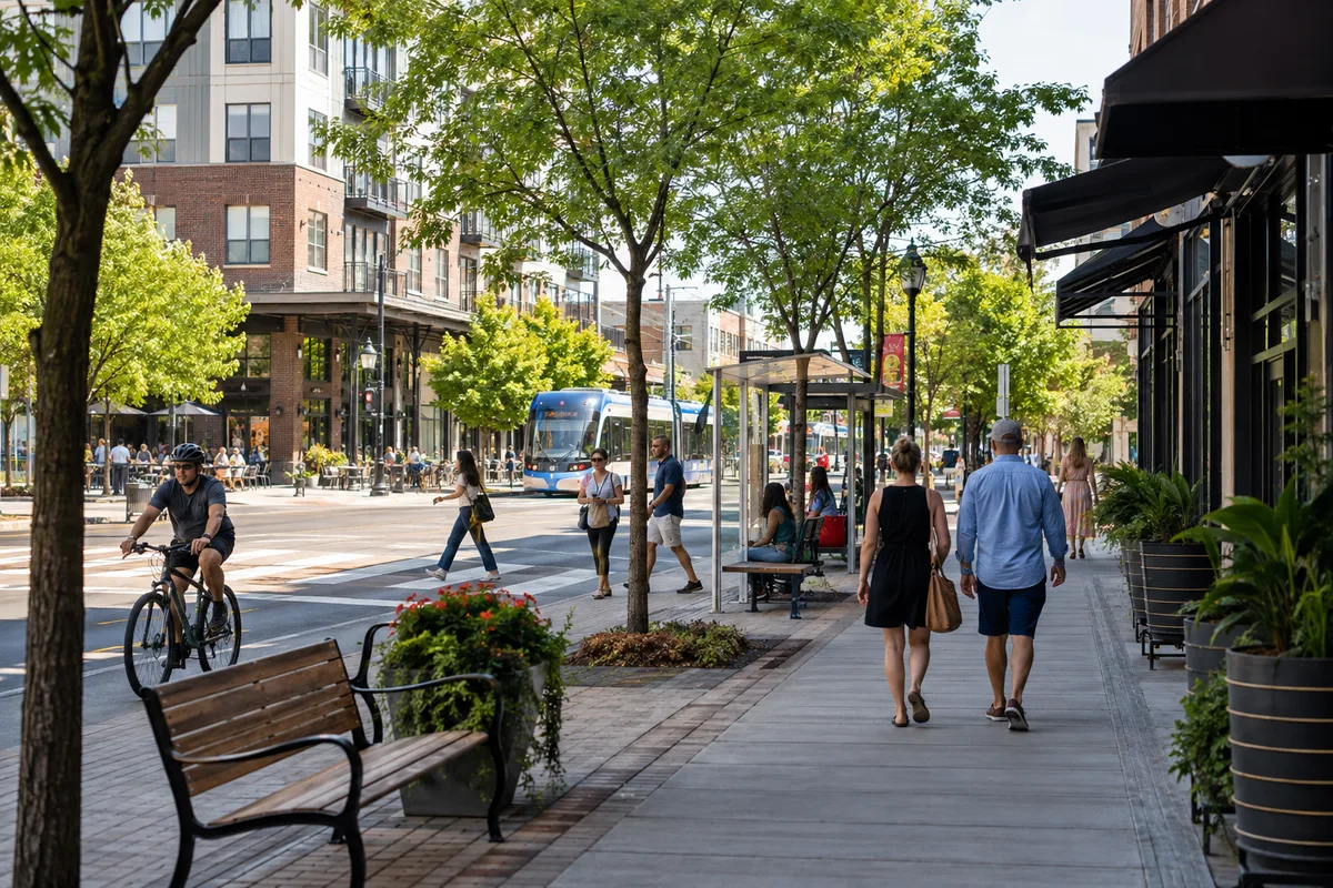
It is tempting to judge walkability by asking whether sidewalks exist.
That is only the beginning.
Imagine walking along a technically complete sidewalk beside six lanes of fast-moving traffic.
There are no trees.
Driveways cut across the pedestrian path every few yards.
Crosswalks are far apart.
Cars turn quickly through intersections.
There are blank walls on one side and parking lots on the other.
You can walk there.
But would you want to?
This reveals one of the most useful distinctions in walkability:
A route can be physically walkable without feeling pedestrian-friendly.
Sidewalk width and condition matter, but so do crossings, traffic speed, lighting, visibility, shade, noise, street activity, accessibility, and the relationship between pedestrians and vehicles.
Walkability is partly infrastructure.
It is also experience.
Crossing the Street Can Determine the Entire Journey
A pedestrian route is only as convenient as its most difficult crossing.
A wide arterial road can act almost like a river running through a neighborhood.
If crossings are infrequent, pedestrians may have to travel well beyond their destination just to reach the other side safely.
If crossing times are short, people who walk slowly may feel rushed.
Complex intersections with several turning lanes can increase the amount of information pedestrians must monitor.
This affects how a city feels.
On a pedestrian-oriented street, intersections are part of the journey.
On a heavily automobile-oriented street, they can feel like obstacles.
That is one reason walkability cannot be understood simply by measuring how many miles of sidewalk a city has.
The continuity of the pedestrian network matters more.
One excellent sidewalk that ends at an intimidating intersection does not create an excellent walking system.
Traffic Speed Changes How a Street Feels
People experience vehicle speed differently when they are sitting inside a car and when they are standing a few feet away from one.
A road designed for fast movement may function efficiently for drivers while creating an uncomfortable pedestrian environment.
Higher speeds can increase noise, make crossings more demanding, and make pedestrians feel less separated from traffic.
Street design influences this perception.
Wide lanes, long uninterrupted road segments, large turning radii, and broad intersections can visually encourage faster vehicle movement.
Narrower pedestrian-oriented environments often create a very different relationship between the street and the people using it.
The important issue is not whether cars are present.
Some of the world’s most enjoyable walking environments still contain traffic.
The question is whether the street has been designed only as a channel for vehicles or as a public space used by many types of people.
Buildings Matter More Than You Might Think
Walkability does not stop at the curb.
The buildings beside the sidewalk change the walking experience too.
Compare these two streets.
The first has:
small storefronts, doors opening onto the sidewalk, windows, cafés, apartments above shops, frequent entrances, and changing visual details.
The second has:
a blank wall, fenced land, loading docks, parking garages, or enormous setbacks between buildings and the street.
Even if the sidewalks are identical, the first route will often feel shorter and more interesting.
Urban designers sometimes describe this in terms of human scale.
People walking move slowly enough to notice windows, entrances, shop displays, landscaping, signs, benches, other pedestrians, and architectural details.
A street designed primarily to be viewed at driving speed can feel visually empty on foot.
This helps explain a strange experience travelers sometimes notice:
A 20-minute walk through a lively historic district can feel shorter than a 10-minute walk beside a parking lot.
The clock has not changed.
The experience has.
Why Mixed-Use Neighborhoods Often Feel Naturally Walkable
Mixed-use neighborhoods place different activities closer together.
Instead of separating housing, employment, shopping, and recreation into distant zones, they allow several functions to exist within the same area.
That changes walking in an important way.
A trip does not have to be made solely for exercise.
You can walk because you need coffee.
Then stop at a pharmacy.
Then buy groceries.
Then continue to the train station.
One journey can accomplish several things.
That combination matters because everyday walking depends heavily on useful destinations.
The EPA’s National Walkability Index specifically incorporates measures of employment and household mix because greater diversity of land uses is associated with more walking trips.
A neighborhood becomes easier to navigate on foot when daily life does not require repeatedly traveling long distances between separate zones.
Public Transportation Can Make an Entire City More Walkable
Walking and public transit are often treated as separate transportation modes.
In practice, they reinforce each other.
Almost every transit journey contains walking.
You walk from your home to the bus stop.
From a train station to work.
From a metro stop to a restaurant.
From one transit line to another.
A strong public transportation network therefore expands the effective range of a pedestrian.
Without transit, a person walking may comfortably reach destinations within perhaps a relatively small area.
With frequent, well-connected transit, walking becomes the first and last part of journeys across the city.
That is why proximity to transit is another component of the EPA’s National Walkability Index.
Walkable cities are not necessarily cities where people walk everywhere.
They are often cities where walking connects smoothly with other ways of getting around.
Shade Can Turn a Walkable Street Into an Actually Walked Street
Urban design can look excellent on a map and still fail in the real world if climate is ignored.
Consider a wide sidewalk during a hot summer afternoon.
If the entire route is exposed to direct sunlight, the technically walkable distance may become physically unpleasant.
Tree canopy, building shade, arcades, awnings, covered walkways, drinking water, and places to rest can dramatically change the pedestrian experience.
The same applies in cold, rainy, windy, or humid environments.
This is another reason a simple walkability score cannot capture every aspect of walking.
The physical distance between destinations may remain identical throughout the year.
The experience of covering that distance may change completely with temperature, shade, precipitation, and wind.
A truly pedestrian-friendly city works with its climate rather than pretending climate does not exist.
Why Some Walks Feel Shorter Than They Really Are
Walkability is also perceptual.
A journey with changing storefronts, trees, people, architecture, cafés, public art, and frequent intersections continually gives the brain new information.
A walk along an enormous blank wall provides much less stimulation.
This can alter the subjective experience of distance.
You may have experienced this while traveling.
Twenty minutes through a lively central neighborhood can pass almost unnoticed.
Ten minutes along a highway frontage road can feel endless.
That does not mean entertainment is a formal requirement for walkability.
It means humans experience distance through more than measurement.
Comfort, visual interest, uncertainty, noise, heat, effort, and perceived safety all influence whether a route feels easy or exhausting.
Feeling Safe Matters—even When Distance Is Identical
Two routes can be geometrically identical and psychologically very different.
One is well lit, visible from nearby buildings, regularly used by other pedestrians, and contains shops that remain open into the evening.
The other is poorly lit, empty, hidden behind fences, and isolated from surrounding buildings.
A map may calculate the same walking time for both.
People may not treat them as equivalent.
Walkability research therefore increasingly recognizes perceived safety and surveillance alongside physical street characteristics.
This does not mean busy streets are automatically safe or empty streets automatically dangerous.
Perception and actual risk are not identical.
But if people consistently feel uncomfortable using a route, the pedestrian network is not functioning for them in the same way it appears to function on a planning map.
Why Tourists Notice Walkability So Quickly
Travel makes urban design unusually visible.
At home, people often know which trips require a car, which bus to take, where parking is available, and which streets to avoid.
In an unfamiliar city, those habits disappear.
Suddenly the structure of the city becomes obvious.
Can you leave your hotel and reach breakfast on foot?
Is the museum 12 minutes away by a direct route—or 12 minutes away on a map but separated by an enormous intersection?
Can you walk from one attraction to another?
Is public transportation close enough to reach easily?
Does the neighborhood remain pleasant after dark?
This is one reason walkability can strongly influence the experience of slow travel and longer stays in a destination. Staying in one neighborhood becomes much more rewarding when everyday needs, public transportation, local businesses, and interesting streets can be reached without constantly arranging another journey.
For travelers, walkability often determines how much of a city they experience between its famous attractions.
Density Helps—but Density Alone Does Not Create Walkability
Dense cities are often associated with walking because density can place more people and destinations within a smaller area.
But high density does not guarantee a good pedestrian experience.
A neighborhood can contain tall apartment towers yet still be surrounded by:
- giant roads
- isolated superblocks
- enormous parking facilities
- few nearby shops
- difficult pedestrian crossings
Likewise, a lower-rise neighborhood can be highly walkable if it has connected streets, mixed uses, frequent destinations, safe crossings, and good transit access.
Density helps support walkability.
It does not replace good design.
This is an important distinction because otherwise the formula becomes too simple:
dense = walkable
low-density = unwalkable
Real cities are more complicated.
Density is best understood as an enabling condition rather than a guarantee.
Higher density can place more destinations within a smaller area, but walkability also depends on street connectivity, safe crossings, sidewalks, traffic conditions, transit access and the quality of the pedestrian environment.
Why Walkability Scores Cannot Tell You Everything
Walkability indices are useful.
They allow researchers, planners, and residents to compare places using measurable characteristics.
The EPA’s National Walkability Index, for example, ranks U.S. block groups using variables related to:
- intersection density
- proximity to transit
- employment mix
- employment and household mix
Those variables capture important structural characteristics.
But the EPA itself notes that numerous factors influence walking and that the index uses a limited set of variables because they can be measured consistently nationwide.
That limitation is important.
A numerical index may not fully capture:
shade.
sidewalk quality.
crossing comfort.
noise.
street trees.
architecture.
topography.
maintenance.
weather.
perceived safety.
A neighborhood that scores well statistically can still contain unpleasant pedestrian routes.
Another that performs modestly on a broad index may have individual streets that are exceptional.
So walkability scores are best understood as tools—not final judgments about what every pedestrian will experience.
Walkability Is Different for Different People
There is no single universal pedestrian.
A smooth 15-minute walk for one person may be difficult or inaccessible for someone else.
Walkability changes with:
- age
- mobility
- disability
- stroller use
- sidewalk condition
- curb design
- hill gradient
- crossing time
- access to seating
- heat
- snow
- lighting
This is why accessibility belongs inside serious discussions of walkability rather than being treated as a separate bonus feature.
A street that works only for fast-moving, able-bodied adults is not equally walkable for the entire population.
The most successful pedestrian environments give many different people realistic ways to move through them.
Can a Car-Oriented City Become More Walkable?
Yes, but adding a sidewalk beside every existing road is not enough.
Walkability emerges from a network.
Cities can improve that network by creating more direct pedestrian connections, safer crossings, continuous sidewalks, better transit access, mixed-use development, shade, street trees, lighting, seating, and environments where useful destinations are closer together.
Some changes can happen relatively quickly.
A dangerous crossing can be redesigned.
A missing sidewalk segment can be completed.
Shade can be added.
Other changes take decades because land-use patterns and street networks are difficult to transform once development has already spread across a large area.
The goal does not have to be eliminating cars.
It is giving people a realistic choice not to use one for every single trip.
The Best Walkable Cities Make Walking Feel Like the Obvious Option
The difference between a walkable city and an unwalkable one is often invisible until you try to go somewhere.
Then every design decision becomes noticeable.
How far away is the destination?
Is there a direct route?
Can you cross the street?
Is there continuous sidewalk?
Are the blocks manageable?
Can transit extend the journey?
Is there shade?
Does the street feel interesting?
Does walking feel comfortable enough that you would choose to do it again tomorrow?
No single feature answers all of those questions.
That is why walkability is better understood as a system rather than a sidewalk score.
The most walkable cities do not merely allow people to walk.
They arrange everyday life so that walking frequently feels like the simplest thing to do.
Sources
CDC — Designing Activity-Friendly Communities
Systematic Review — Walkability and Urban Built Environments








Join the discussion